A geofence is a very useful tool for managing vehicle fleets. Even when a dispatcher handles the fleet successfully, geofencing prevents vehicles from traveling through areas that could cause conflicts, problems, or disrupt daily operations.
A geofence is a very useful tool for managing vehicle fleets. Even when a dispatcher handles the fleet successfully, geofencing prevents vehicles from traveling through areas that could cause conflicts, problems, or disrupt daily operations.
At Hunter, we offer it as part of the Hunter Track GPS Tracking solution to help optimize fleet management and make the most of your resources. But do you know exactly what Geofences are and whether you can implement them in your business? Keep reading this blog to learn a little more about them.
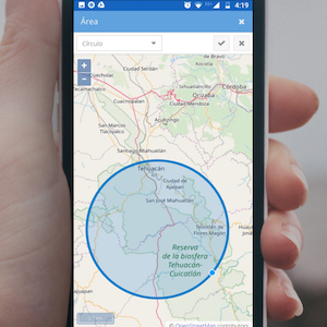
Geofences are zones or territories defined virtually on a digital map, within which a vehicle or person can move freely. Once they are set up, any person or vehicle that actually crosses them automatically sends a signal that it has done so.
They are usually included in GPS Tracking Systems for vehicles or GPS for people, since these are the tools used to monitor and track the movement of people, cargo, and vehicles.
To set up a Geofence, you need a digital platform that includes a map. There, you draw shapes or lines on the geographic coordinates where you want to limit movement.
Next, you set up a system of alerts or notifications that indicate when the Geofence has been crossed. From then on, any vehicle or person carrying the GPS device can be confirmed on the platform as moving within the defined areas.
If they cross the boundary, the GPS automatically triggers an alarm or notification indicating that the Geofence limit has been crossed. In practice, this lets you determine whether employees are in their assigned zone and working in the right place.
Geofences are an essential part of the Hunter Track GPS Tracking System. While our experience shows the main reasons a company may use them, every business can implement them for its own reasons.
Would you like to learn more and confirm whether you can implement them in your company? If so, feel free to contact us and request advice from our expert technicians by calling 809.620.2002. You can also visit our website, hunter.do, to explore the complete Hunter Track solution, which includes Geofences.